Last month we took a bird's eye view of North Point Street and the surrounding neighbourhood of North Beach, San Fransisco. Now let's get down on the ground for a look around.
There are seemingly endless sources of information on the history of San Fransisco - one of the advantages of modelling a railroad in a popular, historical city I suppose. But finding information on North Point Street specifically has proven a bit more difficult.
The neighbourhood of North Beach lies in the shadow of the Coit Tower and Telegraph Hill, boxed in by the Bay on two sides, and Columbia Street to the west. The area has long been known for its Italian cultural heritage. The Sanborn maps and phone directories from the era speak to this in the names found for businesses and dwellings alike.
North Point Street was, until the rapid urbanization of the '70s, mostly a light industrial and commercial strip, home to a variety of manufacturers, warehouses, and other businesses. Many of these relied on the SBRR for rail service over the years. Only a few of the buildings that housed these companies remain today and evidence of rail service has also all but disappeared.
This post will keep us focused on some of the interesting features around North Point Street from the railway point of view, and attempt to capture the look and feeling of the area in the immediate post-WWII era. For better reference while reading this post, I suggest looking at the maps provided in my previous blog post.
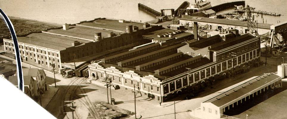
The image above, circa 1930s, marks the foot of North Point Street (heading off to the right, across the front of the Harbor Warehouse building). We are looking down Kearny, with the main SBRR tracks in the cobblestones in the foreground heading along the waterfront Embarcadero. The Harbor Warehouse complex of four buildings was rail served in two spots, including from North Point. See my previous blog post for an arial view, where the photographer here would be standing at the bottom left of the image.
The damage to the warehouse seems to be the focus of this series of images - perhaps due to a derailment. The track that leads to North Point comes very close to the corner of this building, as does the one heading down Kearny, which crosses the North Point spur at a diamond in front of the damaged corner.
The cobblestones, low-rise warehouses, and rails in the streets are key characteristics of this area of the city and of North Point. One of the things I found interesting in these images is the number of structures sheathed in corrugated metal (including the damaged Harbour Warehouse). This is something I thought was more common in later years.
The above image was taken from Grant Street at the foot of Beach Street (one street closer to the water paralleling North Point). Era is unknown, but from the businesses and freight cars it appears to be pre-1940s, probably even earlier. The road appears paved, however - at least for another block or two. I haven't seen that in many images from before the late 1930s. On the right is one of the small SBRR yards, and just behind the yard is the intersection with Powell Street, then a Pacific Gas & Electric gasometer and Power House stacks mentioned as major landmarks in a previous blog post.
The two images above are Bay Street, which was a block further off the water from North Point. The stacks of the Power House show up again in the first of the two images. The Davis Hardwood company yard in these images shared the block with the Simmons Mattress Company. I haven't determined yet when Simmons might have taken over this end of the block. Elusive North Point is on the far side of the Davis yard. The taller warehouse in the distance of the second image is Lyon Van and Storage. It will appear again in a photo further along in this post, and the opposite side of it is easily seen in this image from a previous blog post.
The tracks in the worn cobblestones in the first image are for the Powell Street streetcar which continued to the waterfront, crossing North Point between two of the Simmons buildings (see next image in this post). The line terminated at what is now Fisherman's Wharf. Bay Street appears to be dirt road - although in very good condition.
If this post were a survey of Powell Street, we would be in a much better position it seems. A block closer to the water and looking back up Powell from the previous photo above, this is the first good image I have been able to find of the Simmons Mattress manufacturing buildings and its stylish overhead walkways. It is also the first image I have found that is actually of North Point, even if the elusive street just crosses in the foreground of this image.
The Powell Street streetcar makes the location easier to identify. You can also make out the sign for "Bimbo's Restaurant" down the block on the right, which according to the 1938 Bay Area phone directory was located at 2299 Powell - essentially the same address of "Fitzgerald's Salon" in the two previous photos taken at Powell and Bay. It is interesting to see how the area has developed in the twenty some years between these two photos: paved streets, more substantial structures, etc. The street lamps attached to the utility poles are an interesting detail to be recreated if I can find a better image of the ornate brackets. Also of note is that the streetcar overhead catenary was carried on its own poles and not the utility poles, adding to the already cluttered streetscape.
Back on a (now paved) Bay Street in the mid-1930s, we look eastward towards Powell Street, Fitzgerald's and Davis Hardwood (obscured behind the Cable Car). There are several good photos in this series of the intersection and turning of the cable car on OpenSFHistory.org. Lyons Van & Storage features again as a landmark on this street. California Steel next door on the corner is a vacant lot by the circa-1950 view of North Beach from this previous blog post. The Simmons Mattress buildings can be seen in the distance on the left, immediately behind the cable car (above the gentleman using all his might to turn the car).
Last, but not least, is not a ground-level photo but one I just had to include. Friend and fellow model railroader Don Marenzi recently pointed me to this image of the large Del Monte (ex. California Fruit Canners Association, nee California Packing Company) complex. Later serving as one of many Haslett Company warehouses in this area, the buildings had apparently been considered for a museum space, and still stand today as "The Cannery," a complex of shops and hotel. The complex is located on Beach and Leavenworth, at the very foot of Columbus.
The number of boxcars lined up between and outside the complex speak to its significance for the SBRR, and plans are to make this a feature industry on my layout. There was a fourth spur to the complex on Jefferson (on the far side of the buildings in this image). That spur came off of the Belt trackage on its way to the tunnel under Fort Mason and to the Presidio, both off to the left (west) in this image on Jefferson Street. Jefferson a storey or so lower at this point, as you can see from the sloping street and sidewalk on the near side of the building.
The track curving off to the left behind the houses in the centre of this image is the end of the North Point spur, which stopped at Ghirardelli just two blocks away.
It was interesting digging through the many resources online to uncover these images - particularly as there are so many of the North Beach neighbourhood, but so few of North Point Street itself. Trying to find good images of trackside structures along North Point has so far been a big challenge. I'm sure between the non-digitized archives and the numerous sources I haven't scoured yet, more will turn up over time.
There are seemingly endless sources of information on the history of San Fransisco - one of the advantages of modelling a railroad in a popular, historical city I suppose. But finding information on North Point Street specifically has proven a bit more difficult.
The neighbourhood of North Beach lies in the shadow of the Coit Tower and Telegraph Hill, boxed in by the Bay on two sides, and Columbia Street to the west. The area has long been known for its Italian cultural heritage. The Sanborn maps and phone directories from the era speak to this in the names found for businesses and dwellings alike.
North Point Street was, until the rapid urbanization of the '70s, mostly a light industrial and commercial strip, home to a variety of manufacturers, warehouses, and other businesses. Many of these relied on the SBRR for rail service over the years. Only a few of the buildings that housed these companies remain today and evidence of rail service has also all but disappeared.
This post will keep us focused on some of the interesting features around North Point Street from the railway point of view, and attempt to capture the look and feeling of the area in the immediate post-WWII era. For better reference while reading this post, I suggest looking at the maps provided in my previous blog post.
 |
| Looking "south" down Kearny, circa 1930. North Point Street heads off to the right of this image. Calisphere, UofC Digital Library. |
The image above, circa 1930s, marks the foot of North Point Street (heading off to the right, across the front of the Harbor Warehouse building). We are looking down Kearny, with the main SBRR tracks in the cobblestones in the foreground heading along the waterfront Embarcadero. The Harbor Warehouse complex of four buildings was rail served in two spots, including from North Point. See my previous blog post for an arial view, where the photographer here would be standing at the bottom left of the image.
The damage to the warehouse seems to be the focus of this series of images - perhaps due to a derailment. The track that leads to North Point comes very close to the corner of this building, as does the one heading down Kearny, which crosses the North Point spur at a diamond in front of the damaged corner.
The cobblestones, low-rise warehouses, and rails in the streets are key characteristics of this area of the city and of North Point. One of the things I found interesting in these images is the number of structures sheathed in corrugated metal (including the damaged Harbour Warehouse). This is something I thought was more common in later years.
 |
| Looking "west" down Beach Street at Grant/Embarcadero. Detail of a slide from Worthpoint.com. |
The above image was taken from Grant Street at the foot of Beach Street (one street closer to the water paralleling North Point). Era is unknown, but from the businesses and freight cars it appears to be pre-1940s, probably even earlier. The road appears paved, however - at least for another block or two. I haven't seen that in many images from before the late 1930s. On the right is one of the small SBRR yards, and just behind the yard is the intersection with Powell Street, then a Pacific Gas & Electric gasometer and Power House stacks mentioned as major landmarks in a previous blog post.
 |
| Bay and Powell looking north-north west circa 1920. OpenSFHistory.org |
 |
| Bay and Powell, looking north-west down Bay circa 1920. OpenSFHistory.org |
The two images above are Bay Street, which was a block further off the water from North Point. The stacks of the Power House show up again in the first of the two images. The Davis Hardwood company yard in these images shared the block with the Simmons Mattress Company. I haven't determined yet when Simmons might have taken over this end of the block. Elusive North Point is on the far side of the Davis yard. The taller warehouse in the distance of the second image is Lyon Van and Storage. It will appear again in a photo further along in this post, and the opposite side of it is easily seen in this image from a previous blog post.
The tracks in the worn cobblestones in the first image are for the Powell Street streetcar which continued to the waterfront, crossing North Point between two of the Simmons buildings (see next image in this post). The line terminated at what is now Fisherman's Wharf. Bay Street appears to be dirt road - although in very good condition.
 |
| North Point and Powell, looking south up Powell towards downtown, circa 1940. SBRR tracks cross in the foreground. The walkway connects two of the Simmons Mattress buildings. OpenSFHistory.org |
If this post were a survey of Powell Street, we would be in a much better position it seems. A block closer to the water and looking back up Powell from the previous photo above, this is the first good image I have been able to find of the Simmons Mattress manufacturing buildings and its stylish overhead walkways. It is also the first image I have found that is actually of North Point, even if the elusive street just crosses in the foreground of this image.
The Powell Street streetcar makes the location easier to identify. You can also make out the sign for "Bimbo's Restaurant" down the block on the right, which according to the 1938 Bay Area phone directory was located at 2299 Powell - essentially the same address of "Fitzgerald's Salon" in the two previous photos taken at Powell and Bay. It is interesting to see how the area has developed in the twenty some years between these two photos: paved streets, more substantial structures, etc. The street lamps attached to the utility poles are an interesting detail to be recreated if I can find a better image of the ornate brackets. Also of note is that the streetcar overhead catenary was carried on its own poles and not the utility poles, adding to the already cluttered streetscape.
 |
| The caption on the image above says it all. This is looking "east" down Bay, towards the water and Powell Street circa 1934. OpenSFHistory.org |
Back on a (now paved) Bay Street in the mid-1930s, we look eastward towards Powell Street, Fitzgerald's and Davis Hardwood (obscured behind the Cable Car). There are several good photos in this series of the intersection and turning of the cable car on OpenSFHistory.org. Lyons Van & Storage features again as a landmark on this street. California Steel next door on the corner is a vacant lot by the circa-1950 view of North Beach from this previous blog post. The Simmons Mattress buildings can be seen in the distance on the left, immediately behind the cable car (above the gentleman using all his might to turn the car).
 |
| "The Cannery", aka Del Monte, from circa 1930. FoundSF.org |
The number of boxcars lined up between and outside the complex speak to its significance for the SBRR, and plans are to make this a feature industry on my layout. There was a fourth spur to the complex on Jefferson (on the far side of the buildings in this image). That spur came off of the Belt trackage on its way to the tunnel under Fort Mason and to the Presidio, both off to the left (west) in this image on Jefferson Street. Jefferson a storey or so lower at this point, as you can see from the sloping street and sidewalk on the near side of the building.
The track curving off to the left behind the houses in the centre of this image is the end of the North Point spur, which stopped at Ghirardelli just two blocks away.
It was interesting digging through the many resources online to uncover these images - particularly as there are so many of the North Beach neighbourhood, but so few of North Point Street itself. Trying to find good images of trackside structures along North Point has so far been a big challenge. I'm sure between the non-digitized archives and the numerous sources I haven't scoured yet, more will turn up over time.
Comments
Post a Comment